Marandurenda moambue'ỹre (18 000 × 18 000 píxeles; tamaño de archivo: 85,34 MB; tipo MIME: image/jpeg)

Ko marandurenda haꞌehína Wikimedia Commons guive ha ikatu ojeipuru ambue tembiaporãme. Pe ñemombeꞌupy oĩva marandurenda ñemombeꞌupy kuatia ryepýpe ojehechauka koꞌápe.

Atención El archivo original tiene un número considerable de píxeles; si se abre en su resolución original, es posible que no se cargue correctamente o que provoque un bloqueo en el funcionamiento del navegador. Para evitar estos problemas puede utilizarse ZoomViewer. Abrir en ZoomViewer

Lower-resolution versions: 6000px, 3000px, and 1000px

Resumen

Mombe'uanga
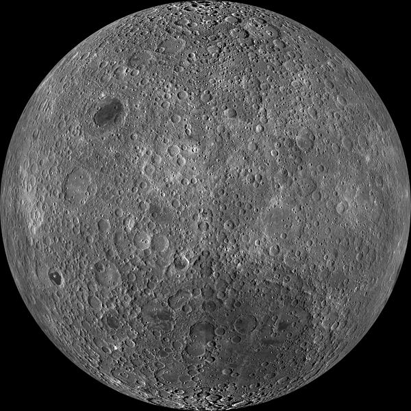
English: Far side of the moon, by NASA's Lunar Reconnaissance Orbiter. Orthographic projection centred at 180° longitude, 0° latitude.

Because the moon is tidally locked (meaning the same side always faces Earth), it was not until 1959 that the farside was first imaged by the Soviet Luna 3 spacecraft (hence the Russian names for prominent farside features, such as Mare Moscoviense). And what a surprise – unlike the widespread maria on the nearside, basaltic volcanism was restricted to a relatively few, smaller regions on the farside, and the battered highlands crust dominated. A different world from what we saw from Earth.

Of course, the cause of the farside/nearside asymmetry is an interesting scientific question. Past studies have shown that the crust on the farside is thicker, likely making it more difficult for magmas to erupt on the surface, limiting the amount of farside mare basalts. Why is the farside crust thicker? That is still up for debate, and in fact several presentations at this week's Lunar and Planetary Science Conference attempt to answer this question.

The Clementine mission obtained beautiful mosaics with the sun high in the sky (low phase angles), but did not have the opportunity to observe the farside at sun angles favorable for seeing surface topography. This WAC mosaic provides the most complete look at the morphology of the farside to date and will provide a valuable resource for the scientific community. And it's simply a spectacular sight!

The Lunar Reconnaissance Orbiter Camera (LROC) Wide Angle Camera (WAC) is a push-frame camera that captures seven color bands (321, 360, 415, 566, 604, 643, and 689 nm) with a 57 km swath (105 km swath in monochrome mode) from a 50 km orbit. One of the primary objectives of LROC is to provide a global 100 m/px monochrome (643 nm) base map with incidence angles between 55° and 70° at the equator, lighting that is favorable for morphological interpretations. Each month, the WAC provides nearly complete coverage of the Moon under unique lighting. As an added bonus, the orbit-to-orbit image overlap provides stereo coverage. Reducing all these stereo images into a global topographic map is a big job, which is being led by LROC Team Members from the German Aerospace Center (Deutsches Zentrum für Luft- und Raumfahrt; DLR). Several preliminary WAC topographic products have appeared in LROC featured images over the past year (Orientale basin, Sinus Iridum). The WAC topographic dataset will be completed and released later this year.

The global mosaic released today is comprised of over 15,000 WAC images acquired between November 2009 and February 2011. The non-polar images were map-projected onto the GLD100 shape model (WAC derived 100 m/px DTM), while polar images were map-projected on the LOLA shape model. In addition, the LOLA-derived crossover-corrected ephemeris and an improved camera pointing provide accurate positioning (better than 100 m) of each WAC image.
Arange entre jasypateĩ de 2009 y jasykői de 2011
date QS:P,+2050-00-00T00:00:00Z/7,P1319,+2009-11-00T00:00:00Z/10,P1326,+2011-02-00T00:00:00Z/10
Moõgui oguenohẽ http://wms.lroc.asu.edu/lroc_browse/view/WAC_GL180 (see also http://photojournal.jpl.nasa.gov/catalog/PIA14021)
Apohára NASA/GSFC/Arizona State University
Otras versiones Lower-resolution versions: 6000px, 3000px, and 1000px
Este archivo fue catalogado por
Jet Propulsion Lab
de la Administración Nacional de Aeronáutica y del Espacio (NASA) de los Estados Unidos de Américabajo el identificador de foto: PIA14021.

Esta etiqueta no indica el estado de los derechos de autor del trabajo adjunto. Se requiere una etiqueta de derechos de autor normal. Para más información vea Commons:Sobre las licencias.
Otros idiomas:

Licencia

Public domain Este archivo es de dominio público porque fue creado por la NASA. Las políticas sobre copyright de la NASA estipulan que «el material de la NASA no está protegido con copyright a menos que se indique lo contrario». (Políticas sobre copyright de la NASA o Políticas sobre la utilización de imágenes del Jet Propulsion Laboratory).
Advertencias:
  • El uso del logotipo de la NASA (incluidos el logotipo actual y los anteriores) está restringido.
  • El sitio web de la NASA almacena una gran cantidad de imágenes del Programa Espacial de la URSS, de la Agencia Espacial Federal Rusa y otras agencias espaciales no estadounidenses. Estas imágenes no son de dominio público.
  • Material del Telescopio espacial Hubble puede tener copyright si no proviene explícitamente del Space Telescope Science Institute. [1]
  • Todo el material creado por la sonda espacial SOHO está protegido por copyright y requiere permiso para ser utilizado con fines comerciales o no educativos. [2]
  • Las imágenes que figuran en el sitio web Astronomy Picture of the Day (APOD) pueden tener copyright. [3]
Annotations
InfoField
This image is annotated: View the annotations at Commons

Leyendas

Añade una explicación corta acerca de lo que representa este archivo

Elementos representados en este archivo

representa a español

Marandurenda rembiasakue

Ejopy peteĩ ára/aravo rehe rehecha hag̃ua pe marandurenda ojehechaukaháicha upe jave.

Ára/AravoMichĩháichaTuichakuePuruháraJehaimombyky
ko’ag̃agua23:47 19 jasyapy 201423:47 19 jasyapy 2014 michĩháicha18 000 × 18 000 (85,34 MB)HuntsterHigh resolution mosaic.
04:12 9 jasyrundy 201104:12 9 jasyrundy 2011 michĩháicha1600 × 1600 (1,44 MB)Bubba73{{Information |Description ={{en|1=Far side of the Moon, by NASA's Lunar Recon. Orbiter}} |Source =http://apod.nasa.gov/apod/image/1104/farside_lro1600.jpg |Author =NASA - LRO |Date =2011? |Permission = |other_versions = }

No hay páginas que enlacen a este archivo.

Marandurenda jepuru opaite tembiapópe

Ko'ã ambue wiki oipuru ko marandurenda:

Ver más uso global de este archivo.