Ta'ãnga:China Hong Kong 4 levels localisation.svg

Tamaño de esta previsualización PNG del archivo SVG: 705 × 599 píxeles. Otras resoluciones: 282 × 240 píxeles | 565 × 480 píxeles | 904 × 768 píxeles | 1205 × 1024 píxeles | 2409 × 2048 píxeles | 1000 × 850 píxeles.
Marandurenda moambue'ỹre (archivo SVG, nominalmente 1000 × 850 píxeles, tamaño de archivo: 703 kB)
| Mombe'uanga |
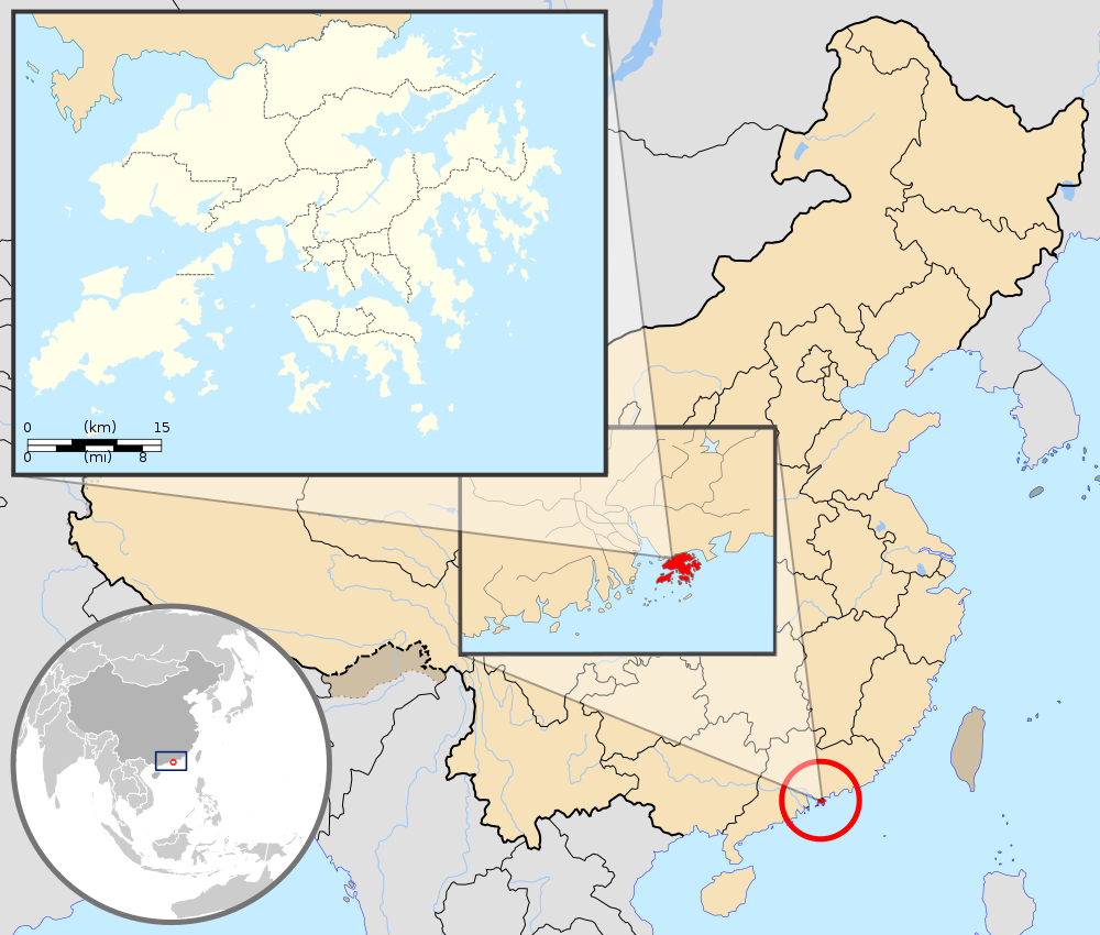
English: Map showing Hong Kong's location in Asia, on China's south coast, and Hong Kong's 18 districts
Français : Carte de Hong Kong : situation en Asie, situation sur le littoral chinois, carte des 18 districts
中文(繁體):顯示香港在亞洲,中國南海岸和香港18區的位置的地圖 |
| Arange | (UTC) |
| Moõgui oguenohẽ |
|
| Apohára |
|
| Otras versiones | Derivative works of this file: Hebao island map.jpg |
| Esta es una imagen retocada, lo que significa que ha sido alterada digitalmente de su versión original. Modificaciones: Combination, color correction. La original se puede ver aquí: China Hong Kong.svg. Las modificaciones las hizo Pethrus.
|
Este archivo se encuentra bajo la licencia Creative Commons Genérica de Atribución/Compartir-Igual 3.0.
Atribución: GFDL
- Nde reime sãsóme:
- de compartir – de copiar, distribuir y transmitir el trabajo
- de remezclar – de adaptar el trabajo
- Bajo las siguientes condiciones:
- atribución – Debes otorgar el crédito correspondiente, proporcionar un enlace a la licencia e indicar si realizaste algún cambio. Puedes hacerlo de cualquier manera razonable pero no de manera que sugiera que el licenciante te respalda a ti o al uso que hagas del trabajo.
- compartir igual – En caso de mezclar, transformar o modificar este trabajo, deberás distribuir el trabajo resultante bajo la misma licencia o una compatible como el original.
Registro original de carga
This image is a derivative work of the following images:
- File:Hong_Kong_Location.svg licensed with PD-self
- 2008-08-27T13:27:11Z Joowwww 1270x640 (234741 Bytes) a few minor tweaks
- 2008-08-27T13:18:03Z Joowwww 1270x640 (234389 Bytes) new version: more detailed, colours are standard with most other locator maps
- 2008-04-20T13:54:51Z Joowwww 1270x640 (79729 Bytes) reduced height, removed map border and added rivers and hk's maritime border
- 2008-04-09T11:31:22Z Joowwww 1270x977 (66085 Bytes) {{Information |Description=A map showing Hong Kong's location in Asia, in China and on China's south coast. |Source=self-made |Date=2008-04-09 |Author= [[User:Joowwww|Joowwww]] |Permission={{PD-self}} |other_versions= }} {{Cr
- File:Map_of_Hong_Kong_18Districts_ZH.svg licensed with Cc-by-sa-3.0, GFDL
- 2008-07-05T21:14:26Z Moddlyg 1454x1083 (381097 Bytes) == Summary == {{Information |Description={{en|1=Map of Hong Kong & 18 Districts (Chinese Version)}} |Source=Own work by uploader |Author={{User:Moddlyg/Sign}} |Date=2008/7/6 |Permission= |other_versions= }} {{ImageUpload|ful
- 2008-07-05T20:59:35Z Moddlyg 1454x1083 (262750 Bytes) {{Information |Description={{en|1=Map of Hong Kong & 18 Districts (Chinese Version)}} |Source=Own work by uploader |Author=~~~ |Date=2008/7/6 |Permission= |other_versions= }}
- File:China_Hong_Kong.svg licensed with PD-self
- 2008-08-13T16:22:08Z Joowwww 1000x850 (212124 Bytes) added missing laos/vietnam border
- 2008-05-14T11:14:46Z Joowwww 1000x850 (210515 Bytes) {{Information |Description=An SVG map of China with Hong Kong special administrative region highlighted and circled Legend:[[Image:China map legend.png]] |Source=self-made; based on CIA public domain maps: *http://www.lib.ut
Uploaded with derivativeFX
Marandurenda rembiasakue
Ejopy peteĩ ára/aravo rehe rehecha hag̃ua pe marandurenda ojehechaukaháicha upe jave.
| Ára/Aravo | Michĩháicha | Tuichakue | Puruhára | Jehaimombyky | |
|---|---|---|---|---|---|
| ko’ag̃agua | 21:33 22 jasyporundy 2019 | | 1000 × 850 (703 kB) | En rouge | added map scale, for the higher resolution sub-picture |
| 07:57 14 jasypo 2015 |  | 1000 × 850 (686 kB) | Flappiefh | Fixed colour of Haïnan. | |
| 18:40 5 jasyapy 2010 |  | 1000 × 850 (685 kB) | Pethrus | {{Information |Description={{en|1=Map showing Hong Kong's location in Asia, on China's south coast, and Hong Kong's 18 disctricts}} {{fr|1=Carte de Hong Kong : situation en Asie, situation sur le littoral chinois, carte des 18 disctricts}} |Source=*[[:Fil |
Marandurenda jeporu
La siguiente página usa este archivo:
Marandurenda jepuru opaite tembiapópe
Ko'ã ambue wiki oipuru ko marandurenda:
- Jeporu ami.wikipedia.org rehe
- Jeporu as.wikipedia.org rehe
- Jeporu azb.wikipedia.org rehe
- Jeporu bh.wikipedia.org rehe
- Jeporu bo.wikipedia.org rehe
- Jeporu br.wikipedia.org rehe
- Jeporu cbk-zam.wikipedia.org rehe
- Jeporu dty.wikipedia.org rehe
- Jeporu dz.wikipedia.org rehe
- Jeporu en.wikipedia.org rehe
- Jeporu fi.wikipedia.org rehe
- Jeporu fr.wikipedia.org rehe
- Jeporu fr.wikinews.org rehe
- Jeporu fr.wiktionary.org rehe
- Jeporu fur.wikipedia.org rehe
- Jeporu gcr.wikipedia.org rehe
- Jeporu incubator.wikimedia.org rehe
- Jeporu io.wikipedia.org rehe
- Jeporu it.wikipedia.org rehe
- Jeporu ja.wikipedia.org rehe
- Jeporu li.wikipedia.org rehe
- Jeporu lld.wikipedia.org rehe
- Jeporu lo.wikipedia.org rehe
- Jeporu mad.wikipedia.org rehe
- Jeporu mai.wikipedia.org rehe
Ver más uso global de este archivo.