Ta'ãnga:Ireland (MODIS).jpg
Tamaño de esta previsualización: 436 × 600 píxeles. Otras resoluciones: 174 × 240 píxeles | 349 × 480 píxeles | 558 × 768 píxeles | 745 × 1024 píxeles | 1600 × 2200 píxeles.
Marandurenda moambue'ỹre (1600 × 2200 píxeles; tamaño de archivo: 2,69 MB; tipo MIME: image/jpeg)
Resumen
| Mombe'uanga |
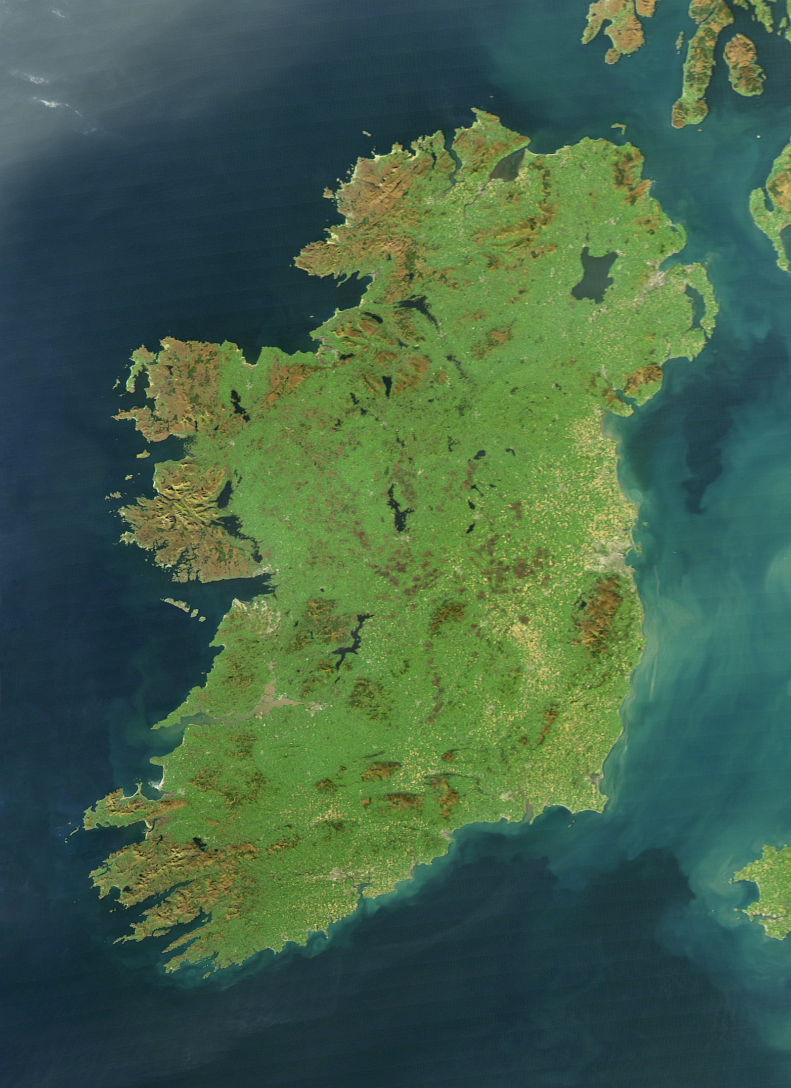
English: It is easy to see from this true-colour image why Ireland is called the Emerald Isle. Intense green vegetation, primarily grassland, covers most of the country except for the exposed rock on mountaintops. Ireland owes its greenness to moderate temperatures and moist air. The Atlantic Ocean, particularly the warm currents in the North Atlantic Drift, gives the country a more temperate climate than most others at the same latitude. |
| Arange | |
| Moõgui oguenohẽ | NASA Earth Observatory |
| Apohára | Jeff Schmaltz |
| Otras versiones |
|
.jpg)
The cloud-free view shown here is extremely rare. The Moderate Resolution Imaging Spectroradiometer (MODIS) on NASA’s Aqua satellite captured the image on October 11, 2010, a time of year when Irish weather alternates between rainstorms from the west and cool, dry weather brought by high pressure systems known as anticyclones.
Licencia
| Este archivo es de dominio público porque fue creado por la NASA. Las políticas sobre copyright de la NASA estipulan que «el material de la NASA no está protegido con copyright a menos que se indique lo contrario». (Políticas sobre copyright de la NASA o Políticas sobre la utilización de imágenes del Jet Propulsion Laboratory). | ||
 |
Advertencias:
|
Marandurenda rembiasakue
Ejopy peteĩ ára/aravo rehe rehecha hag̃ua pe marandurenda ojehechaukaháicha upe jave.
| Ára/Aravo | Michĩháicha | Tuichakue | Puruhára | Jehaimombyky | |
|---|---|---|---|---|---|
| ko’ag̃agua | 12:14 4 jasypoapy 2017 | | 1600 × 2200 (2,69 MB) | Blight55 | quality degraded from original, taken from original |
| 10:04 21 jasyrundy 2017 |  | 1600 × 2200 (1,16 MB) | Blight55 | No borders in space, removed clouds | |
| 20:18 25 jasypakõi 2011 |  | 1600 × 2200 (532 kB) | Tóraí | Less sever colour adjustments from original. | |
| 13:41 13 jasypakõi 2011 |  | 1512 × 1928 (800 kB) | Soerfm | Brightness, crop | |
| 10:22 17 jasyapy 2011 |  | 1600 × 2200 (409 kB) | Originalwana | {{Information |Description ={{en|1=It is easy to see from this true-colour image why Ireland is called the Emerald Isle. Intense green vegetation, primarily grassland, covers most of the country except for the exposed rock on mountaintops. Ireland |
Marandurenda jeporu
La siguiente página usa este archivo:
Marandurenda jepuru opaite tembiapópe
Ko'ã ambue wiki oipuru ko marandurenda:
- Jeporu af.wikipedia.org rehe
- Jeporu ar.wikipedia.org rehe
- Jeporu arz.wikipedia.org rehe
- Jeporu ast.wikipedia.org rehe
- Jeporu az.wikipedia.org rehe
- Jeporu be-tarask.wikipedia.org rehe
- Jeporu br.wikipedia.org rehe
- Jeporu ca.wikipedia.org rehe
- Jeporu ceb.wikipedia.org rehe
- Jeporu cy.wikipedia.org rehe
- Jeporu da.wikipedia.org rehe
- Jeporu de.wikipedia.org rehe
- Jeporu el.wikipedia.org rehe
- Jeporu en.wikipedia.org rehe
- Ireland
- Geography of Ireland
- Gaelic Athletic Association
- Irish Rugby Football Union
- Swim Ireland
- Sport in Ireland
- United Ireland
- Rugby League Ireland
- Irish Real Tennis Association
- Irish Sailing Association
- Hurlingham Polo Association
- List of fractals by Hausdorff dimension
- Cricket Ireland
- Australian Rules Football League of Ireland
- Baseball in Ireland
- Irish Ice Hockey Association
- Baseball Ireland
- Fencing Ireland
- Olympic Federation of Ireland
- Ladies' Gaelic Football Association
- Softball in Ireland
- Pitch and Putt Union of Ireland
- Cycling Ireland
- Horse Sport Ireland
- Basketball Ireland
- Tennis Ireland
- Boxing Union of Ireland
- Parachute Association of Ireland
- Football Association of Ireland
- Hockey Ireland
Ver más uso global de este archivo.
.jpg)
.jpg)