Ta'ãnga:Nile River and delta from orbit.jpg

Nile_River_and_delta_from_orbit.jpg(700 × 550 píxeles; tamaño de archivo: 85 kB; tipo MIME: image/jpeg)

Ko marandurenda haꞌehína Wikimedia Commons guive ha ikatu ojeipuru ambue tembiaporãme. Pe ñemombeꞌupy oĩva marandurenda ñemombeꞌupy kuatia ryepýpe ojehechauka koꞌápe.

Resumen

Mombe'uanga

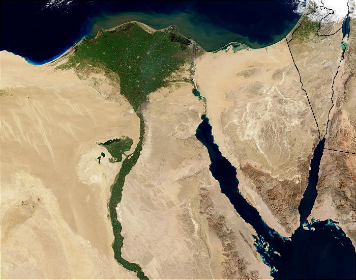
Nile River and delta from orbit Description: The Nile River and delta as seen from space by the MODIS sensor on the Terra satellite.

"Against the barren desert of northeastern Africa, the fertile valley of the Nile River runs northward through Egypt. In the higher-resolution images, the city of Cairo can be seen as a gray smudge right where the river widens into its broad fan-shaped delta. Other cities are dotted across the green landscape, giving it a speckled appearance. Where the Nile empties into the Mediterranean Sea (top) the waters are swirling with color, likely a mixture of sediment, organic matter, and possibly marine plant life. Farther west, the bright blue color of the water is likely less-organically rich sediment, perhaps sand.
"East of the delta lies the arid Sinai Peninsula, whose pointed tip is home to rugged mountains, some as high as 8,600 feet. The lattice work of pale lines marks the paths of ephemeral rivers. The Sinai Peninsula intrudes into the Red Sea. Farther east are Israel, Jordan, and Saudi Arabia. At top right is the disputed territory of the West Bank.
"In the false-color image, vegetation is bright green, water is dark blue or black, and clouds are light blue. It's interesting to notice that places that seem essentially arid, or desert-like in the true-color image in fact have a delicate layer of vegetation. For example, the central Sinai Peninsula, and most of Israel have a faint greenish tinge in the false-color images.
Arange
Moõgui oguenohẽ http://visibleearth.nasa.gov/view_rec.php?id=4927 [1]
Apohára Jacques Descloitres, MODIS Rapid Response Team, NASA/sh
Otras versiones Cuaggjacgacugvajgca

Salchicha

Licencia

Public domain Este archivo es de dominio público porque fue creado por la NASA. Las políticas sobre copyright de la NASA estipulan que «el material de la NASA no está protegido con copyright a menos que se indique lo contrario». (Políticas sobre copyright de la NASA o Políticas sobre la utilización de imágenes del Jet Propulsion Laboratory).
Advertencias:
  • El uso del logotipo de la NASA (incluidos el logotipo actual y los anteriores) está restringido.
  • El sitio web de la NASA almacena una gran cantidad de imágenes del Programa Espacial de la URSS, de la Agencia Espacial Federal Rusa y otras agencias espaciales no estadounidenses. Estas imágenes no son de dominio público.
  • Material del Telescopio espacial Hubble puede tener copyright si no proviene explícitamente del Space Telescope Science Institute. [2]
  • Todo el material creado por la sonda espacial SOHO está protegido por copyright y requiere permiso para ser utilizado con fines comerciales o no educativos. [3]
  • Las imágenes que figuran en el sitio web Astronomy Picture of the Day (APOD) pueden tener copyright. [4]

Leyendas

Añade una explicación corta acerca de lo que representa este archivo
delta del río Nilo

Elementos representados en este archivo

representa a español

5 jasykõi 2003

tipo de archivo español

image/jpeg

Marandurenda rembiasakue

Ejopy peteĩ ára/aravo rehe rehecha hag̃ua pe marandurenda ojehechaukaháicha upe jave.

Ára/AravoMichĩháichaTuichakuePuruháraJehaimombyky
ko’ag̃agua22:47 29 jasypateĩ 200422:47 29 jasypateĩ 2004 michĩháicha700 × 550 (85 kB)MschlindweinNile River and delta from orbit

La siguiente página usa este archivo:

Marandurenda jepuru opaite tembiapópe

Ko'ã ambue wiki oipuru ko marandurenda:

Ver más uso global de este archivo.