Ta'ãnga:Noord-Holland position.svg

Tamaño de esta previsualización PNG del archivo SVG: 200 × 236 píxeles. Otras resoluciones: 203 × 240 píxeles | 407 × 480 píxeles | 651 × 768 píxeles | 868 × 1024 píxeles | 1736 × 2048 píxeles.
Marandurenda moambue'ỹre (archivo SVG, nominalmente 200 × 236 píxeles, tamaño de archivo: 158 kB)
Resumen
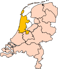
| Mombe'uanga | Location of the province of Noord-Holland (North Holland) in the Netherlands. |
| Arange | |
| Moõgui oguenohẽ | Own work, based on freely available GIS data |
| Apohára | User:Mtcv |
| Permiso (Reutilización de este archivo) |
Data: attribution required; my work: PD |
| Otras versiones | I attempted to make an svg version of Image:Noord Holland-Position.png (with less simplified boundaries) |
Clickable version

Licencia

|
El propietario de los derechos de autor de este archivo, Centraal Bureau voor de Statistiek, autoriza a cualquier persona a usarlo para cualquier propósito, siempre que el titular de los derechos de autor sea atribuido apropiadamente. La redistribución, la realización de trabajos derivados, el uso comercial y otro tipo de usos están permitidos. |
Atribución:
|
| Annotations | This image is annotated: View the annotations at Commons |


Marandurenda rembiasakue
Ejopy peteĩ ára/aravo rehe rehecha hag̃ua pe marandurenda ojehechaukaháicha upe jave.
| Ára/Aravo | Michĩháicha | Tuichakue | Puruhára | Jehaimombyky | |
|---|---|---|---|---|---|
| ko’ag̃agua | 17:20 2 jasyapy 2019 | | 200 × 236 (158 kB) | Thayts | update |
| 15:13 2 jasypa 2006 |  | 200 × 236 (158 kB) | Mtcv | {{Information| |Description=Location of the province of Noord-Holland (North Holland) in the Netherlands. |Source=Own work, based on freely available GIS data |Date=2006-10-02 |Author=User:Mtcv |Permission=Data: attribution required; my work: PD |othe |
Marandurenda jeporu
No hay páginas que enlacen a este archivo.
Marandurenda jepuru opaite tembiapópe
Ko'ã ambue wiki oipuru ko marandurenda:
- Jeporu ar.wikipedia.org rehe
- أمستردام
- شمال-هولندا
- هلفرسوم
- ألكمار
- هارلم (شمال-هولندا)
- زانستاد
- هارلمرمير
- قالب:بلديات شمال هولندا
- سخاخن
- دن هيلدر
- فيلسن
- زانتفورت
- بلوميندال
- ألسمير
- لاندسمير
- أوستزان
- تيسل
- أمستلفين
- إنكهاوزن
- هورن (هولندا)
- فاترلاند
- بيمستر
- بيفيرفايك
- بيرخن (شمال هولندا)
- بلاريكوم
- هيمستيده
- بوابة:أمستردام/قوالب
- بوابة:أمستردام
- حكومة أمستردام
- هارلمرليده آن سبارنفاودا
- آودر- أمستل
- ديمين
- فيسب (هولندا)
- كاستركوم
- دريخترلاند
- إدام- فولندام
- هيمسكيرك
- هيرهوخوفارد
- هيلو (هولندا)
- هولاندز كرون
- هاوزن
- كوخينلاند
- لانجادايك
- لارين (هولندا)
- ميديمبليك
- أوبمير
- بورميراند
- ستيده بروك
- آوتخيست
- آوتهورن
Ver más uso global de este archivo.