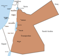
PalestineAndTransjordan.png(636 × 599 píxeles; tamaño de archivo: 65 kB; tipo MIME: image/png)

Ko marandurenda haꞌehína Wikimedia Commons guive ha ikatu ojeipuru ambue tembiaporãme. Pe ñemombeꞌupy oĩva marandurenda ñemombeꞌupy kuatia ryepýpe ojehechauka koꞌápe.

File:PalestineAndTransjordan.svg es una versión vectorial de este archivo. Debería usarse esa versión en lugar de este archivo PNG, cuando sea mejor.

File:PalestineAndTransjordan.png → File:PalestineAndTransjordan.svg

Para más información, lee Ayuda:SVG.

En otros idiomas
Alemannisch  Bahasa Indonesia  Bahasa Melayu  British English  català  čeština  dansk  Deutsch  eesti  English  español  Esperanto  euskara  français  Frysk  galego  hrvatski  Ido  italiano  lietuvių  magyar  Nederlands  norsk bokmål  norsk nynorsk  occitan  Plattdüütsch  polski  português  português do Brasil  română  Scots  sicilianu  slovenčina  slovenščina  suomi  svenska  Tiếng Việt  Türkçe  vèneto  Ελληνικά  беларуская (тарашкевіца)  български  македонски  нохчийн  русский  српски / srpski  татарча/tatarça  українська  ქართული  հայերեն  বাংলা  தமிழ்  മലയാളം  ไทย  한국어  日本語  简体中文  繁體中文  עברית  العربية  فارسی  +/−
Nueva imagen SVG

Mombe'uanga
English: Map of the British Mandate of Palestine and Transjordan.
Note: Wasserstein, Bernard (2004). Israel and Palestine: Why They Fight and Can They Stop?, pp. 105–106."Palestine, therefore, was not partitioned in 1921–1922. Transjordan was not excised but, on the contrary, added to the mandatory area. Zionism was barred from seeking to expand there – but the Balfour Declaration had never previously applied to the area east of the Jordan. Why is this important? Because the myth of Palestine's 'first partition' has become part of the concept of 'Greater Israel' and of the ideology of Jabotinsky's Revisionist movement."
Moõgui oguenohẽ

Originally uploaded on the English Wiki (all linking to en.wikipedia):

08:13, 8 June 2005 Doron (Talk / contribs) uploaded "Image:PalestineAndTransjordan.png"
Apohára User:Doron
Permiso
(Reutilización de este archivo)
GNU head Se autoriza la copia, distribución y modificación de este documento bajo los términos de la licencia de documentación libre GNU, versión 1.2 o cualquier otra que posteriormente publique la Fundación para el Software Libre; sin secciones invariables, textos de portada, ni textos de contraportada. Se incluye una copia de la dicha licencia en la sección titulada Licencia de Documentación Libre GNU.
w:es:Creative Commons
atribución compartir igual
Este archivo se encuentra bajo la licencia Creative Commons Genérica de Atribución/Compartir-Igual 3.0.
Nde reime sãsóme:
  • de compartir – de copiar, distribuir y transmitir el trabajo
  • de remezclar – de adaptar el trabajo
Bajo las siguientes condiciones:
  • atribución – Debes otorgar el crédito correspondiente, proporcionar un enlace a la licencia e indicar si realizaste algún cambio. Puedes hacerlo de cualquier manera razonable pero no de manera que sugiera que el licenciante te respalda a ti o al uso que hagas del trabajo.
  • compartir igual – En caso de mezclar, transformar o modificar este trabajo, deberás distribuir el trabajo resultante bajo la misma licencia o una compatible como el original.
Esta etiqueta de licencia fue agregada a este archivo como parte de la actualización de la licencia GFDL.
Otras versiones Image:BritishMandatePalestine1920.png

Leyendas

Añade una explicación corta acerca de lo que representa este archivo

Elementos representados en este archivo

representa a español

Marandurenda rembiasakue

Ejopy peteĩ ára/aravo rehe rehecha hag̃ua pe marandurenda ojehechaukaháicha upe jave.

Ára/AravoMichĩháichaTuichakuePuruháraJehaimombyky
ko’ag̃agua15:17 22 jasyapy 201915:17 22 jasyapy 2019 michĩháicha636 × 599 (65 kB)Claude ZygielThis file in clearly definite as "Map of the British Mandate of Palestine '''and''' Transjordan" and used for the both territories
12:01 24 jasypa 201712:01 24 jasypa 2017 michĩháicha636 × 599 (61 kB)Nicola RomaniReverted to version as of 11:02, 22 April 2016 (UTC)
17:04 30 jasypoapy 201717:04 30 jasypoapy 2017 michĩháicha675 × 542 (51 kB)OnceinawhileConverted into new svg - this is the png version
16:07 19 jasypa 201616:07 19 jasypa 2016 michĩháicha636 × 599 (65 kB)Claude ZygielThis file in clearly definite as "Map of the British Mandate of Palestine '''and''' Transjordan" and used for the both territories.
11:02 22 jasyrundy 201611:02 22 jasyrundy 2016 michĩháicha636 × 599 (61 kB)Makeandtossoops
11:01 22 jasyrundy 201611:01 22 jasyrundy 2016 michĩháicha636 × 599 (61 kB)MakeandtossRemoved Mandatory Palestine since picture is used to refer to only the emirate
15:49 4 jasypakõi 201115:49 4 jasypakõi 2011 michĩháicha636 × 599 (66 kB)Wickey-nlthicker lining around lake
21:43 3 jasypakõi 201121:43 3 jasypakõi 2011 michĩháicha636 × 599 (66 kB)Wickey-nlFixed border
15:29 29 jasyteĩ 201115:29 29 jasyteĩ 2011 michĩháicha636 × 599 (77 kB)VadacFixed border of Transjordan within the Mandate of Palestine with Saudi Arabia per the present border having been drawn in 1965 as seen here.
11:29 24 jasykõi 200611:29 24 jasykõi 2006 michĩháicha636 × 599 (89 kB)Lohen11Palestine from:

No hay páginas que enlacen a este archivo.

Marandurenda jepuru opaite tembiapópe

Ko'ã ambue wiki oipuru ko marandurenda:

Ver más uso global de este archivo.

Apopyme'ẽ